
Preview
Date Original
1827
Description
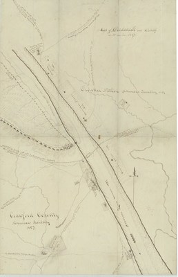
Hand drawn map of Dardanelle and vicinity showing the Cherokee Nation in the Arkansas Territory, the Arkansas River and part of Crawford County. The map also indicates local landmarks at the time as well as the military road going through the area.
Biographical/Historical Note
Located in Yell County, Dardanelle was founded in 1847 and incorporated in 1855.
Physical Description
Map, 11" x 17"
Geographical Area
Dardanelle, Yell County, (Ark.)
Language
English
Identifier
Map0194
Resource Type
Image
Collection
Map collection
Publisher
Arkansas State Archives
Contributing Entity
Arkansas State Archives
Recommended Citation
Map of Dardanelle and Vicinity in 1827, Map0194, Map collection, Arkansas State Archives, Little Rock, Arkansas.
Rights
Use and reproduction of images held by the Arkansas State Archives without prior written permission is prohibited. For information on reproducing images held by the Arkansas State Archives, please call 501-682-6901 or email at state.archives@arkansas.gov.
Disciplines
United States History


