
Preview
Date Original
1885 May 19
Description
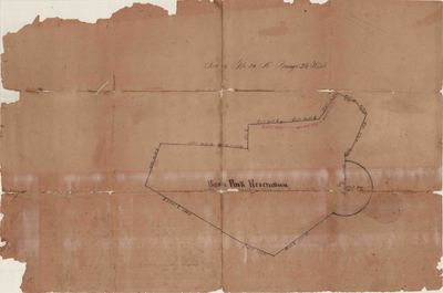
This plat shows the land reservation for Basin Park (now Basin Spring Park) in Eureka Springs.
Biographical/Historical Note
People of various indigenous cultures visited the springs in the area that would become Eureka Springs, believing them to have healing properties, for centuries before Europeans arrived. The town of Eureka Springs was formally incorporated on February 14, 1880. By May of the same year, 2,000 houses had already been constructed, and by 1889, Eureka Springs was the second-largest city in Arkansas, after Little Rock. As the original survey of Eureka Springs by Major I.N. Armstrong had caused property disputes across the city in this time of rapid expansion, the Basin Spring Reservation has to be re-platted. On April 6, 1885, a federal court ruled that all the springs in the city and the reservations surrounding them were to be given over to the public for free use. The new plat of the Reservation was made on May 19, 1885, by T.P. German.
Physical Description
Map, 19.75" x 13"
Keywords
Maps; Hotels; Springs; Resorts; Health resorts; Land use
Geographical Area
Eureka Springs, Carroll County. (Ark.)
Language
English
Identifier
Map2271
Resource Type
Image
Collection
Map collection
Publisher
Arkansas State Archives
Contributing Entity
Arkansas State Archives
Recommended Citation
Plat of the Basin Park Reservation, Eureka Springs, 1885, Map2271, Map collection, Arkansas State Archives, Little Rock, Arkansas.
Rights
Use and reproduction of images held by the Arkansas State Archives without prior written permission is prohibited. For information on reproducing images held by the Arkansas State Archives, please call 501-682-6901 or email at state.archives@arkansas.gov.
Disciplines
United States History
Additional Content
Keywords
Maps; Hotels; Springs; Resorts; Health resorts; Land use


