
Title
Map and Profile of the Proposed Road From Opposite Memphis, Tennessee, to the St. Francis River
Preview
Date Original
1833
Description
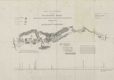
Black and white printed map and profile of the proposed road from opposite Memphis, Tennessee, to the St. Francis River and also showing the adjacent country. Surveyed under the direction of W. Howard, U.S. Corps of Engineers, by C.N. Hagner, J.W. Smith, W. Beckwith, and M.H. Stansbury. The map was drawn by C.N. Hagner.
Physical Description
Map: 22.5" x 16.5"
Keywords
Roads; Surveying; Surveyors
Contributor
United States Corps of Engineers; M.H. Stansbury
Geographical Area
Memphis, Tennessee, St. Francis River
Language
English
Identifier
Map1432
Resource Type
Image
Collection
Map collection
Publisher
Arkansas State Archives
Contributing Entity
Arkansas State Archives
Recommended Citation
Map and Profile of the Proposed Road From Opposite Memphis, Tennessee, to the St. Francis River, Map1432, Map collection, Arkansas State Archives, Little Rock, Arkansas.
Rights
Use and reproduction of images held by the Arkansas State Archives without prior written permission is prohibited. For information on reproducing images held by the Arkansas State Archives, please call 501-682-6901 or email at state.archives@arkansas.gov.
Disciplines
United States History
Additional Content
Keywords
Roads; Surveying; Surveyors


