
Preview
Date Original
1836
Description
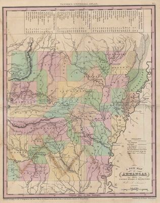
Printed color map of Arkansas with its canals, roads, distances, towns and counties. There is a legend on the side of the map showing steamboat routes. The map was part of Tanner's Universal Atlas.
Biographical/Historical Note
Henry Schenck Tanner was born in 1786 in New York. He was a cartographer and statistical geographer and owned a publishing company in Philadelphia. He is best known for publishing the New American Atlas. Tanner died in 1858. Arkansas became a territory in 1819 and became a state in 1836.
Physical Description
Map, 12.5" x 16.5"
Keywords
Waterways; Roads
Contributor
Clerk's Office of the Eastern District of Pennsylvania
Geographical Area
Arkansas
Language
English
Identifier
Map0069
Resource Type
Image
Collection
Map collection
Publisher
Arkansas State Archives
Contributing Entity
Arkansas State Archives
Recommended Citation
A New Map of Arkansas With its Canals, Roads and Distances, Map0069, Map collection, Arkansas State Archives, Little Rock, Arkansas.
Rights
Use and reproduction of images held by the Arkansas State Archives without prior written permission is prohibited. For information on reproducing images held by the Arkansas State Archives, please call 501-682-6901 or email at state.archives@arkansas.gov.
Disciplines
United States History
Additional Content
Keywords
Waterways; Roads


