
Preview
Date Original
1871
Description
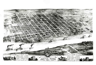
Illustrated map of Little Rock, Arkansas, showing the settlement of the city, the Arkansas River with steamboats and images of buildings found in Little Rock along the bottom of the map. There are also listings of important buildings and churches in the city. The map shows the layout of the named streets.
Biographical/Historical Note
Established in 1820, Little Rock is situated on the south bank of the Arkansas River.
Physical Description
Map, 25.25" x 14.25"
Geographical Area
Little Rock, Pulaski County, (Ark.)
Language
English
Identifier
Map0243
Resource Type
Image
Collection
Map collection
Publisher
Arkansas State Archives
Contributing Entity
Arkansas State Archives
Recommended Citation
Map of Little Rock, Arkansas, Map0243, Map collection, Arkansas State Archives, Little Rock, Arkansas.
Rights
Use and reproduction of images held by the Arkansas State Archives without prior written permission is prohibited. For information on reproducing images held by the Arkansas State Archives, please call 501-682-6901 or email at state.archives@arkansas.gov.
Disciplines
United States History


