
Preview
Date Original
1877
Description
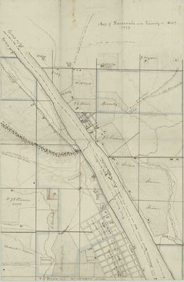
Colored, hand drawn map of Dardanelle,Yell County, Arkansas and its vicinity showing the area as it was in 1876. The map shows the Pope and Yell County line, property owned by various local citizens and a partial town plat of Dardanelle. The map shows that Dardanelle was founded in 1847.
Biographical/Historical Note
Located in Yell County, Dardanelle was founded in 1847 and incorporated in 1855.
Physical Description
Map, 11" x 17"
Geographical Area
Dardanelle, Yell County, (Ark.)
Language
English
Identifier
Map0196
Resource Type
Image
Collection
Map collection
Publisher
Arkansas State Archives
Contributing Entity
Arkansas State Archives
Recommended Citation
Map of Dardanelle and Vicinity, 1877, Map0196, Map collection, Arkansas State Archives, Little Rock, Arkansas.
Rights
Use and reproduction of images held by the Arkansas State Archives without prior written permission is prohibited. For information on reproducing images held by the Arkansas State Archives, please call 501-682-6901 or email at state.archives@arkansas.gov.
Disciplines
United States History


