
Preview
Date Original
1902
Description
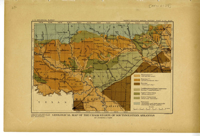
This map shows the geological makeup of the Chalk Region of southwestern Arkansas.
Biographical/Historical Note
During the Paleozoic Era, all of the area that is now Arkansas lay under the ocean. The central and southern areas were under a deeper part of the ocean than the northern part, and so had less marine life but more sand and clay. The remains of marine organisms eventually became limestone, sand became sandstone, silt turned into siltstone, and clay became shale. In the Mesozoic Era, which the Cretaceous Period is part of, southern Arkansas was still underneath the ocean, but the ocean had become shallow. The remains of marine organisms from this period formed chalk, marl, and calcareous clay. Studying the geology of the state helps us understand the forces that have shaped Arkansas over its long history.
Physical Description
Map, 19.75" x 13"
Keywords
Maps; Geology; Mining geology
Contributor
U.S Geological Survey
Geographical Area
Southwestern Arkansas
Language
English
Identifier
Map2263
Resource Type
Image
Collection
Map collection
Publisher
Arkansas State Archives
Contributing Entity
Arkansas State Archives
Recommended Citation
Geological Map of the Chalk Region of Southwestern Arkansas, Map2263, Map collection, Arkansas State Archives, Little Rock, Arkansas.
Rights
Use and reproduction of images held by the Arkansas State Archives without prior written permission is prohibited. For information on reproducing images held by the Arkansas State Archives, please call 501-682-6901 or email at state.archives@arkansas.gov.
Disciplines
United States History
Additional Content
Keywords
Maps; Geology; Mining geology


