
Preview
Date Original
1850
Description
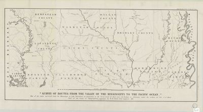
Printed map of the survey of routes through Arkansas from the Mississippi River at Lake Providence, Louisiana, to the great bend of the Red River in Fulton, Arkansas.
Physical Description
Map, 18" x 32"
Keywords
Roads; Surveying
Contributor
Col. J.J. Abert, W.H. Sidell
Geographical Area
Chicot County, Bradley County, Ouachita County, Union County, Dallas County, Hempstead County and Lafayette County, Arkansas and Carrol Parish, Morehouse Parish, Union Parish, Claiborne Parish, Bossier Parish and Caddo Parish, Louisiana
Language
English
Identifier
Map2075
Resource Type
Image
Collection
Map collection
Publisher
Arkansas State Archives
Contributing Entity
Arkansas State Archives
Recommended Citation
Survey of Routes From the Valley of the Mississippi to the Pacific Ocean, Map2075, Map collection, Arkansas State Archives, Little Rock, Arkansas.
Rights
Use and reproduction of images held by the Arkansas State Archives without prior written permission is prohibited. For information on reproducing images held by the Arkansas State Archives, please call 501-682-6901 or email at state.archives@arkansas.gov.
Disciplines
United States History
Additional Content
Keywords
Roads; Surveying


