
Preview
Date Original
1843
Description
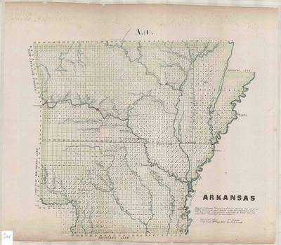
Printed color map of Arkansas's surveying district showing the extent of public surveys on September 30, 1843. The surveyed exteriors are indicated by black lines and subidivided townships are indicated by the letter S.
Biographical/Historical Note
Arkansas became part of the United States when it was included in the Louisiana Purchase in 1803. It became a territory in 1819 and achieved statehood in 1836.
William Pelham had moved to Arkansas Territory with his older brother in 1820. By 1821, Charles was Deputy Surveyor for the U.S. General Land Office, and employed his younger brother as a chain carrier in 1826. While William gained extensive experience in the surveying field, his career was greatly furthered by nepotism and political favoritism. It was mostly the latter which in June 1830 caused President Andrew Jackson: "Reposing special Trust and Confidence in the Ability and Skill of WILLIAM PELHAM of Arkansas" (sic), to appoint him to survey the boundary between Arkansas Territory and Louisiana. His action came on the heels of an appointment of James Conway as Boundary Commissioner.
William Pelham would marry James Conway's younger sister, Mary Ann Conway, in 1831, and James Conway would become Arkansas's first state governor in 1836. Later in his life, William Pelham would hold office as the first Surveyor General of New Mexico, from 1854 until 1860.
Physical Description
Map, 16" x 18"
Contributor
Surveyor's Office in Little Rock, Arkansas
Geographical Area
Arkansas
Language
English
Identifier
Map1868
Resource Type
Image
Collection
Map collection
Publisher
Arkansas State Archives
Contributing Entity
Arkansas State Archives
Recommended Citation
Map of Arkansas Surveying District, Map1868, Map collection, Arkansas State Archives, Little Rock, Arkansas.
Rights
Use and reproduction of images held by the Arkansas State Archives without prior written permission is prohibited. For information on reproducing images held by the Arkansas State Archives, please call 501-682-6901 or email at state.archives@arkansas.gov.
Disciplines
United States History


