
Preview
Date Original
1917
Description
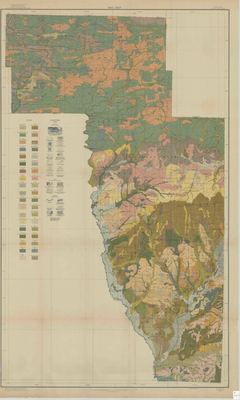
Printed color map of the soils of Howard County, Arkansas. There is a legend on the side of the map indicating which soils can be found in different parts of the county. There is also a legend on the side indicating the different topographical areas of the county.
Biographical/Historical Note
Soil maps are of great use in farming areas, as the type of soil often determines what kinds of crops will grow well there. Sandy loam soils are good for crops that need good drainage, whereas gravelly soils are better suited for fruit trees, and calcareous soils are especially adapted to crops like alfalfa and cotton.
Located in the southwest corner of the state, Howard County was established in 1873. Its county seat is Nashville.
Physical Description
Map, 45" x 27"
Contributor
Hugh H. Bennett, M.W. Beck, M.Y. Longacre, F.A. Hayes, William T. Carter, Jr.
Geographical Area
Howard County, Arkansas
Language
English
Identifier
Map1939
Resource Type
Image
Collection
Map collection
Publisher
Arkansas State Archives
Contributing Entity
Arkansas State Archives
Recommended Citation
Soil map of Howard County, Arkansas, Map1939, Map collection, Arkansas State Archives, Little Rock, Arkansas.
Rights
Use and reproduction of images held by the Arkansas State Archives without prior written permission is prohibited. For information on reproducing images held by the Arkansas State Archives, please call 501-682-6901 or email at state.archives@arkansas.gov.
Disciplines
United States History


