
Preview
Date Original
1890
Description
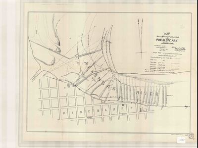
Black and white lithographic print of soundings and the river bank at Pine Bluff in Jefferson County, Arkansas. It shows a partial plat of Pine Bluff and indicates depths of the river and the location of the river bank at different years.
Biographical/Historical Note
Sounding is the act of measuring the depth of a body of water at different points for navigation purposes. Traditional terms for soundings are a source for common expressions in the English language, notably "deep six" (a sounding of 6 fathoms). On the Mississippi River in the 1800s, the leadsmen doing the soundings also used old-fashioned words for some of the numbers; for example, instead of "two" they would say "twain". Thus when the depth was two fathoms, they would call "by the mark twain!". The American writer Mark Twain, a former river pilot, likely took his pen name from this cry.
Pine Bluff is located in Jefferson County in Southeast Arkansas and was incorporated January 10, 1839. It was named for a bluff of pine trees overlooking the south bank of the Arkansas River.
Physical Description
Map, 16" x 21"
Contributor
A. Hoen & Co.
Geographical Area
Pine Bluff, Jefferson County, (Ark.)
Language
English
Identifier
Map1695
Resource Type
Image
Collection
Map collection
Publisher
Arkansas State Archives
Contributing Entity
Arkansas State Archives
Recommended Citation
Map Showing Soundings and River Bank at Pine Bluff, Arkansas, Map1695, Map collection, Arkansas State Archives, Little Rock, Arkansas.
Rights
Use and reproduction of images held by the Arkansas State Archives without prior written permission is prohibited. For information on reproducing images held by the Arkansas State Archives, please call 501-682-6901 or email at state.archives@arkansas.gov.
Disciplines
United States History


