
Preview
Date Original
1854
Description
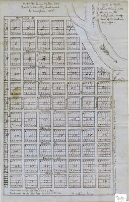
Hand-drawn map on blue paper of the Des Arc in Prairie County, Arkansas. The map shows lots, blocks, and streets. The blocks are numbered or identified by letters. In the upper right corner of the map, "Note by clerk - White River not shown on the original map. Now of record in my office."
Biographical/Historical Note
Located in Eastern Arkansas, Des Arc was one of the earliest settlements in Arkansas. The town was incorporated in 1854, the year this map was created. Des Arc is one of two county seats serving Prairie County.
Physical Description
Map: 17" x 11"
Geographical Area
Des Arc, Prairie County. (Ark.)
Language
English
Identifier
Map1682
Resource Type
Image
Collection
Map collection
Publisher
Arkansas State Archives
Contributing Entity
Arkansas State Archives
Recommended Citation
Map of the Town of Des Arc, Prairie County, Arkansas, Map1682, Map collection, Arkansas State Archives, Little Rock, Arkansas.
Rights
Use and reproduction of images held by the Arkansas State Archives without prior written permission is prohibited. For information on reproducing images held by the Arkansas State Archives, please call 501-682-6901 or email at state.archives@arkansas.gov.
Disciplines
United States History


