
Preview
Date Original
1885
Description
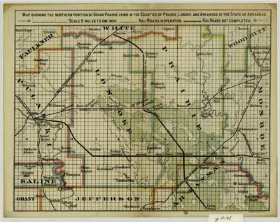
Printed color map of the counties covered by the Grand Prairie in 1885. The map shows the county boundaries, towns, railroad lines, and bodies of water.
Biographical/Historical Note
The Grand Prairie is a subregion of the Arkansas Delta, located between the bottomlands of the White River and the Arkansas River. Today, the Grand Prairie is mostly used for rice farming, but less than one percent of the original prairie remains.
The Woodward and Teirnan Printing Company was founded by William H. Woodward and Luke Tiernan in St. Louis. Woodward was born in England and immigrated to America as a young man and was later instrumental in helping to organize the 1904 St. Louis World's Fair. The printing company operated until the late 1950s.
Physical Description
Map: 9" x 12"
Geographical Area
Lonoke County, Prairie County, Arkansas County, Arkansas
Language
English
Identifier
Map1641
Resource Type
Image
Collection
Map collection
Publisher
Arkansas State Archives
Contributing Entity
Arkansas State Archives
Recommended Citation
Map Showing the Northern Portion of the Grand Prairie Lying in the Counties of Prairie, Lonoke and Arkansas in the State of Arkansas, Map1641, Map collection, Arkansas State Archives, Little Rock, Arkansas.
Rights
Use and reproduction of images held by the Arkansas State Archives without prior written permission is prohibited. For information on reproducing images held by the Arkansas State Archives, please call 501-682-6901 or email at state.archives@arkansas.gov.
Disciplines
United States History


