
Preview
Date Original
1837
Description
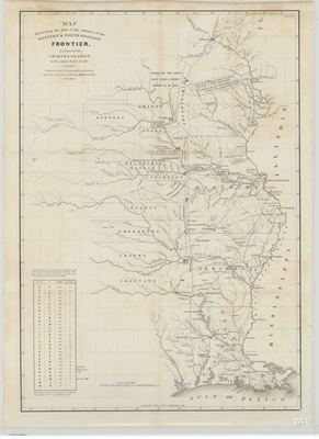
Printed map of Louisiana, Arkansas, Missouri and the Western frontier. The map includes mileage between military posts and depots and the shows the territories of the various Native American tribes.
Biographical/Historical Note
The 1830s was a tumultuous decade in relations between Native American tribes and the U.S. government. With the passing of the Indian Removal Act of 1830, the Native American tribes of the southeastern United States were forcibly relocated from their native lands to Indian Territory, in eastern sections of modern-day Oklahoma.
Physical Description
Map, 23" x 17"
Contributor
U.S. Topographical Bureau, Charles Gratiot, Col. J.J. Abert
Geographical Area
Arkansas, Louisiana, Missouri, Western Frontier
Language
English
Identifier
Map1577
Resource Type
Image
Collection
Map collection
Publisher
Arkansas State Archives
Contributing Entity
Arkansas State Archives
Recommended Citation
Map Illustrating the Plan of the Defenses of the Western and Northwestern Frontier, Map1577, Map collection, Arkansas State Archives, Little Rock, Arkansas.
Rights
Use and reproduction of images held by the Arkansas State Archives without prior written permission is prohibited. For information on reproducing images held by the Arkansas State Archives, please call 501-682-6901 or email at state.archives@arkansas.gov.
Disciplines
United States History


