Files
Download
Download Full Text (1.8 MB)
Date Original
circa 1871
Description
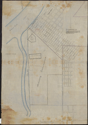
Hand drawn map of Fort Smith from survey done on September 1871. Survey for map done by Boundary Commission.
Physical Description
Map, 26.75" x 37"
Geographical Area
Fort Smith, Sebastian County (Ark.)
Language
English
Identifier
Map0202
Resource Type
Image
Collection
Map collection
Publisher
Arkansas State Archives
Contributing Entity
Arkansas State Archives
Recommended Citation
Map of Fort Smith, Sebastian County, Arkansas, Map0202, Map collection, Arkansas State Archives, Little Rock, Arkansas.
Rights
Use and reproduction of images held by the Arkansas State Archives without prior written permission is prohibited. For information on reproducing images held by the Arkansas State Archives, please call 501-682-6901 or email at state.archives@arkansas.gov.
Preview