Title
Files
Download Full Text (3.8 MB)
Date Original
undated
Description
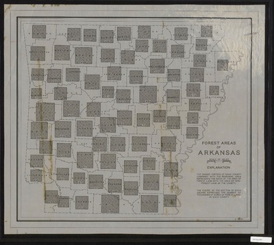
Black and white map entitled "Forest Areas of Arkansas." The explanation notes "The shaded portion of each county compared with the remaining area represents the ratio of the area of forest land with the area of non-forest land in the county. The figure at the bottom of each square expresses the number of thousands of acres of forest land in each county."
Physical Description
Map, 19.25" x 21.75"
Subjects
Forests and forestry
Contributor
S. Smith
Geographical Area
Arkansas
Language
English
Identifier
Map3009
Resource Type
Image
Collection
Map collection
Publisher
Arkansas State Archives
Contributing Entity
Arkansas State Archives
Recommended Citation
Forest Areas of Arkansas, Map3009, Map collection, Arkansas State Archives, Little Rock, Arkansas.
Rights
Use and reproduction of images held by the Arkansas State Archives without prior written permission is prohibited. For information on reproducing images held by the Arkansas State Archives, please call 501-682-6900 or email at state.archives@arkansas.gov.
Preview