Files
Download Full Text (323 KB)
Date Original
1930
Description
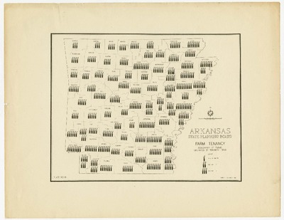
This is a map of farm tenancy in Arkansas from the Arkansas State Planning Board in 1930.
Physical Description
Map, 11" x 8.75"
Subjects
Farmers; Farm life; Farming; Farms; Agriculture; Maps
Contributor
Arkansas State Planning Board
Geographical Area
Arkansas
Language
English
Identifier
MS.000567, Box 1, Folder 12, Item 17
Resource Type
Image
Collection
Works Progress/Work Projects Administration (WPA) Arkansas research files, MS.000567
Publisher
Arkansas State Archives
Contributing Entity
Arkansas State Archives
Recommended Citation
Map, "Arkansas Farm Tenancy", Works Progress/Work Projects Administration (WPA) Arkansas research files, Arkansas State Archives, Little Rock, Arkansas.
Rights
Use and reproduction of images held by the Arkansas State Archives without prior written permission is prohibited. For information on reproducing images held by the Arkansas State Archives, please call 501-682-6900 or email at state.archives@arkansas.gov.
Disciplines
Agriculture | United States History
Preview