
Preview
Date Original
1940 June
Description
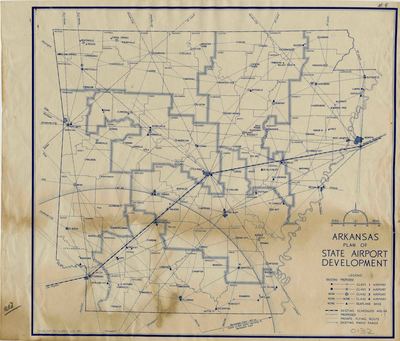
This map shows existing and proposed airports and seaplane bases in Arkansas in 1940, and radio ranges, as well as existing and proposed flying routes between bases.
Biographical/Historical Note
In 1938, Franklin Delano Roosevelt created the Civilian Pilot Training Program in response to the other similar programs in Europe, especially the ones in Italy and Germany. The CPTP trained civilians (including both men and women until the US entered WWII, when only men were admitted) to be pilots with a nine-week course. In 1939, the Central Flying Service, a commercial aircraft firm, was created in Little Rock in response to the CPTP. That year the CPTP commenced in Arkansas in the newly created municipal airport in Fayetteville.
In 1940, Raymond J. Ellis took over the program in Arkansas and founded Fayetteville Flying Services. On May 16, 1940, President Roosevelt called for the production of 50,000 airplanes a year and asked Congress to appropriate $100,000,000 to the President to increase the production of aircraft and anti-aircraft guns, as well as to help train more people to use the new airplanes and weapons. In response, the Civil Aeronautics Authority (CAA), the predecessor to the FAA, announced that it would expand the CPTP.
Physical Description
Map, 12.75" x 10.75"
Keywords
Maps; Airports
Geographical Area
Arkansas
Language
English
Identifier
Map0132
Resource Type
Image
Collection
Map collection
Publisher
Arkansas State Archives
Contributing Entity
Arkansas State Archives
Recommended Citation
Plan of State Airport Development, Map0132, Map collection, Arkansas State Archives, Little Rock, Arkansas.
Rights
Use and reproduction of images held by the Arkansas State Archives without prior written permission is prohibited. For information on reproducing images held by the Arkansas State Archives, please call 501-682-6901 or email at state.archives@arkansas.gov.
Disciplines
United States History
Additional Content
Keywords
Maps; Airports


