
Preview
Date Original
1863
Description
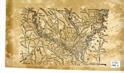
This map depicts a portion of south-eastern Arkansas, including the Arkansas River, the Mississippi River, the White River, other waterways, roadways, raised landforms, prairies, and population centers.
Biographical/Historical Note
There were a number of military engagements along the Arkansas and White Rivers during the Civil War. The Battle of Arkansas Post, also known as the Battle of Fort Hindman, was fought from January 9th-11th in 1863 as a part of the Vicksburg Campaign of the Civil War. Union Major General John A. McLernand captured Fort Hindman near Arkansas Post in order to stop Confederate interference of Union shipping, and to open the way for a possible offensive against Little Rock.
The Battle of St. Charles took place in June of 1862, near St. Charles, Arkansas, along the White River. The naval engagement was fought between eight Union ships, including the USS Mound City, and several Confederate shore guns. Though the Confederate bombardment resulted in heavy Union casualties when the USS Mound City's steam drum exploded and scalded over a hundred of the 175-man crew to death, the Union forces undertook an attack on the Confederate batteries with their infantry soldiers and were able to occupy St. Charles. The site of the land portion of the battle is listed on the National Register of Historic Places as the St. Charles Battle Site.
Physical Description
Map, 12.5" x 7"
Keywords
American Civil War; Rivers; Waterways; Bayous; Maps; Geography
Geographical Area
Arkansas River; White River; Mississippi River; Little Rock, Pulaski County. (Ark.); Arkansas Post, Arkansas County. (Ark.); Helena, Phillips County. (Ark.); Pine Bluff, Arkansas County. (Ark.)
Language
English
Identifier
Map2190
Resource Type
Image
Collection
Map collection
Publisher
Arkansas State Archives
Contributing Entity
Arkansas State Archives
Recommended Citation
Map of Operations on Arkansas, White River, Map2190, Map collection, Arkansas State Archives, Little Rock, Arkansas.
Rights
Use and reproduction of images held by the Arkansas State Archives without prior written permission is prohibited. For information on reproducing images held by the Arkansas State Archives, please call 501-682-6901 or email at state.archives@arkansas.gov.
Disciplines
United States History
Additional Content
Keywords
American Civil War; Rivers; Waterways; Bayous; Maps; Geography


