
Preview
Date Original
1936
Description
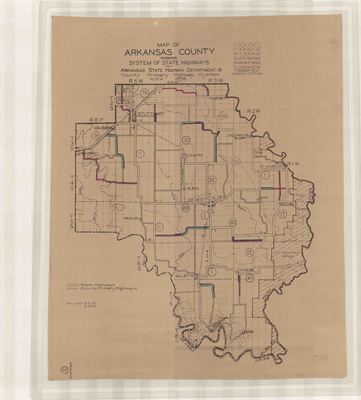
Printed map of the highway system in Arkansas County, Arkansas. The map shows towns, highways, rivers and water fowl refuge. In the upper right corner of the map, there is a legend for township plats showing sections.
Biographical/Historical Note
Located in the southeast corner of the state, Arkansas County was established in 1813. It was dual county seats in DeWitt and Stuttgart. Arkansas County is one of Arkansas's original counties. Originally called the State Highway Commission, the Arkansas State Highway Department was established by Act 302 in 1913 before there was an established state highway system. It also renamed the Department of State Lands to the Department of State Lands, Highways and Improvements. In 1923, Arkansas passed the Harrelson Road Law establishing a system of highways throughout the state. In 1929, the highway department was separated from the Department of State Lands and Improvements and put under the State Highway Commission.
Physical Description
Map, 21" x 17"
Contributor
Works Progress Administration
Geographical Area
Arkansas County, Arkansas
Language
English
Identifier
Map1789
Resource Type
Image
Collection
Map collection
Publisher
Arkansas State Archives
Contributing Entity
Arkansas State Archives
Recommended Citation
Map of Arkansas County Showing System of State Highways, Map1789, Map collection, Arkansas State Archives, Little Rock, Arkansas.
Rights
Use and reproduction of images held by the Arkansas State Archives without prior written permission is prohibited. For information on reproducing images held by the Arkansas State Archives, please call 501-682-6901 or email at state.archives@arkansas.gov.
Disciplines
United States History


