
Preview
Date Original
1851
Description
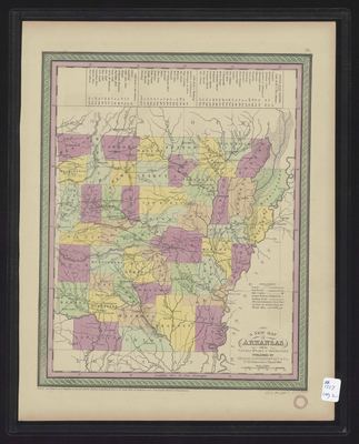
Printed color map of Arkansas. At the top of the map is a list of steamboat routes.
Biographical/Historical Note
Arkansas became part of the United States when it was included in the Louisiana Purchase in 1803. It became a territory in 1819 and achieved statehood in 1836.
Physical Description
Map, 17" x 14"
Keywords
Waterways; Roads
Contributor
Clerk's Office of the District Court of the Eastern District of Pennsylvania
Geographical Area
Arkansas
Language
English
Identifier
Map1557
Resource Type
Image
Collection
Map collection
Publisher
Arkansas State Archives
Contributing Entity
Arkansas State Archives
Recommended Citation
A New Map of Arkansas With its Canals, Roads and Distances, Map1557, Map collection, Arkansas State Archives, Little Rock, Arkansas.
Rights
Use and reproduction of images held by the Arkansas State Archives without prior written permission is prohibited. For information on reproducing images held by the Arkansas State Archives, please call 501-682-6901 or email at state.archives@arkansas.gov.
Disciplines
United States History
Additional Content
Keywords
Waterways; Roads


