Files
Download Full Text (4.5 MB)
Date Original
1937-02-26
Description
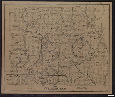
Map of Forest Protection Unit No. 13, including highways, truck trails, other roads, lookout towers, forest telephone lines, unit boundaries, and unit headquarters. Includes northern border of Ozarks National Forest.
Physical Description
Map, 29.25" x 35"
Subjects
Fire lookout stations; Watchtowers
Geographical Area
Carroll County (Ark.); Boone County (Ark.); Marion County (Ark.); Searcy County (Ark.); Newton County (Ark.)
Language
English
Identifier
Map2980
Resource Type
Image
Collection
Map collection
Publisher
Arkansas State Archives
Contributing Entity
Arkansas State Archives
Recommended Citation
Map of Forest Protection Unit No. 13, Map2980, Map collection, Arkansas State Archives, Little Rock, Arkansas.
Rights
Use and reproduction of images held by the Arkansas State Archives without prior written permission is prohibited. For information on reproducing images held by the Arkansas State Archives, please call 501-682-6900 or email at state.archives@arkansas.gov.
Preview