Files
Download Full Text (3.8 MB)
Date Original
1881
Description
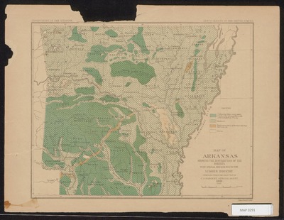
Color map of Arkansas showing the distribution of the forests throughout the state. Includes a legend distinguishing yellow pine, loblolly pine, hardwood, region from which all merchantable pine has been cut, and prairie. From the tenth census of the United States.
Physical Description
Map, 8.5" x 11.5"
Subjects
Timber; Lumber trade
Contributor
C.S. Sargent; Department of the Interior; Julius Bien & Co. lith.
Geographical Area
Arkansas
Language
English
Identifier
Map0291
Resource Type
Image
Collection
Map collection
Publisher
Arkansas State Archives
Contributing Entity
Arkansas State Archives
Recommended Citation
Map of Arkansas showing the distribution of the forests from the tenth census of the United States, Map0291, Map collection, Arkansas State Archives, Little Rock, Arkansas.
Rights
Use and reproduction of images held by the Arkansas State Archives without prior written permission is prohibited. For information on reproducing images held by the Arkansas State Archives, please call 501-682-6900 or email at state.archives@arkansas.gov.
Preview