Files
Download Full Text (1.7 MB)
Date Original
1933-1938
Description
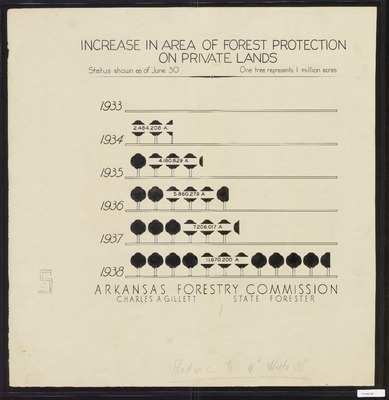
Graph entitled "Increase in Area of Forest Protection on Private Lands" from 1933-1938, featuring tree shapes for each year with each tree representing 1 million acres of forest protection.
Physical Description
Document, 23.25" x 23.5"
Subjects
Arkansas State Forestry Commission; Forests and forestry
Contributor
Arkansas State Forestry Commission; Charles A. Gillett, State Forester
Geographical Area
Arkansas
Language
English
Identifier
Map3122
Resource Type
Image
Collection
Map collection
Publisher
Arkansas State Archives
Contributing Entity
Arkansas State Archives
Recommended Citation
1933-1938 Graph of Increase in Area of Forest Protection on Private Lands, Map3122, Map collection, Arkansas State Archives, Little Rock, Arkansas.
Rights
Use and reproduction of images held by the Arkansas State Archives without prior written permission is prohibited. For information on reproducing images held by the Arkansas State Archives, please call 501-682-6900 or email at state.archives@arkansas.gov.
Preview