Files
Download Full Text (4.8 MB)
Date Original
1936
Description
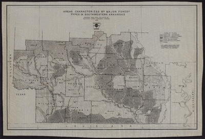
Black and white map entitled "Areas Characterized by Major Forest Types in Southwestern Arkansas," including forest types of shortleaf hardwoods, shortleaf loblolly hardwoods, mixed upland hardwoods, mixed bottomlands hardwoods, and prairie lands. Prepared from data collected by Southern Forest Experiment Station.
Physical Description
Map, 20.25" x 29.25"
Subjects
Arkansas State Forestry Commission; Forests and forestry; Southern Forest Experiment Station (New Orleans, La.)
Contributor
Arkansas State Forestry Commission; Southern Forest Experiment Station (New Orleans, La.)
Geographical Area
Sevier County (Ark.); Howard County (Ark.); Little River County (Ark.); Miller County (Ark.); Lafayette County (Ark.); Columbia County (Ark.); Columbia County (Ark.); Union County (Ark.); Ashley County (Ark.); Hempstead County (Ark.); Nevada County (Ark.); Ouachita County (Ark.); Calhoun County (Ark.); Bradley County (Ark.); Drew County (Ark.); Lincoln County (Ark.); Cleveland County (Ark.); Dallas County (Ark.); Clark County (Ark.); Pike County (Ark.); Hot Spring County (Ark.); Grant County (Ark.)
Language
English
Identifier
Map3088
Resource Type
Image
Collection
Map collection
Publisher
Arkansas State Archives
Contributing Entity
Arkansas State Archives
Recommended Citation
Map of Areas Characterized by Major Forest Types in Southwestern Arkansas, Map3088, Map collection, Arkansas State Archives, Little Rock, Arkansas.
Rights
Use and reproduction of images held by the Arkansas State Archives without prior written permission is prohibited. For information on reproducing images held by the Arkansas State Archives, please call 501-682-6900 or email at state.archives@arkansas.gov.
Preview