Files
Download Full Text (4.3 MB)
Date Original
1929
Description
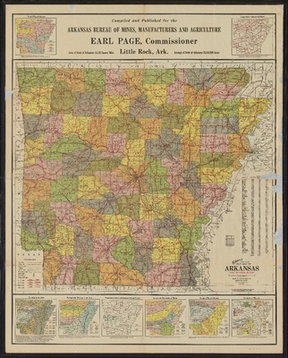
Color Ohman's Standard New Map of Arkansas, "The Wonder State," including maps of soils of the state, physiographic divisions, boundaries of Ozark and Arkansas National Forests, distribution of timber, minerals and geological map, rainfall, and temperature.
Physical Description
Map, 31" x 39.5"
Subjects
Timber; Soils; Ozark National Forest (Ark.); Minerals; Geology; Rain and rainfall
Contributor
Theo W. Ohman; Earl Page, Commissioner, Arkansas Bureau of Mines, Manufactures and Agriculture
Geographical Area
Arkansas
Language
English
Identifier
Map0124
Resource Type
Image
Collection
Map collection
Publisher
Arkansas State Archives
Contributing Entity
Arkansas State Archives
Recommended Citation
Ohman's Standard New Map of Arkansas, Map0124, Map collection, Arkansas State Archives, Little Rock, Arkansas.
Rights
Use and reproduction of images held by the Arkansas State Archives without prior written permission is prohibited. For information on reproducing images held by the Arkansas State Archives, please call 501-682-6900 or email at state.archives@arkansas.gov.
Preview