
Preview
Date Original
1870-1930
Description
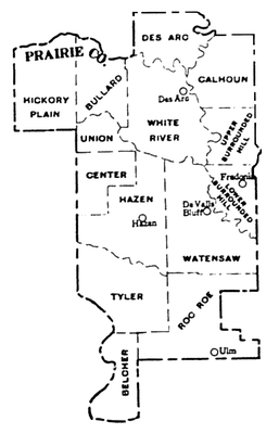
Map of Prairie County, Arkansas, with the following townships: Belcher, Bullard, Calhoun, Center, Des Arc, Hazen, Hickory Plain, Lower Surrounded Hill, Roc Roe, Tyler, Union, Upper Surrounded Hill, Watensaw, and White River. This image was isolated from the 1930 Bureau of the Census' Arkansas Minor Civil Divisions [map].
Physical Description
Microfilm
Keywords
Counties; Arkansas--Administrative and political divisions--Maps
Geographical Area
Prairie County (Ark.)
Language
English
Identifier
MG2530, 1930.42 Arkansas Minor Civil Divisions [map], Prairie County
Resource Type
Image
Collection
General microfilm collection, MG2530 [County township maps, 1930]
Publisher
Arkansas State Archives
Contributing Entity
Arkansas State Archives
Recommended Citation
Bureau of the Census. “[Prairie County section of] Arkansas Minor Civil Divisions [map].” in the United States Census of Population 1930.42, Washington, D.C., U.S. Government Printing Office, 1934.
Rights
Use and reproduction of images held by the Arkansas State Archives without prior written permission is prohibited. For information on reproducing images held by the Arkansas State Archives, please call 501-682-6900 or email at state.archives@arkansas.gov.
Disciplines
United States History
Keywords
Counties; Arkansas--Administrative and political divisions--Maps


