
Title
Preview
Date Original
1952-1954
Description
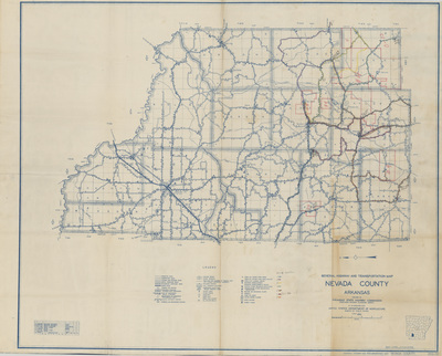
This map of Nevada County, 1952-1954, illustrates county and school district boundaries, school location, and school bus routes, with notes of race.
Biographical/Historical Note
In 1949, the Arkansas Department of Education began issuing county maps to record data necessary to determining transportation aid allocations for each county. Initially, the maps showed the school levels and the race of students at each location. The bus routes also noted what race they were to carry. This racial distinction is not shown in the maps printed after desegregation.
Physical Description
Map, 36" x 45"
Keywords
School districts Arkansas; School buses; Bus stops; Segregation; Maps; Nevada County (Ark.)
Geographical Area
Nevada County (Ark.)
Language
English
Identifier
MS.000449, Nevada County, 1952-1954
Resource Type
Image
Collection
Arkansas Department of Education school district maps, MS.000449
Contributing Entity
Arkansas State Archives
Recommended Citation
Nevada County, 1952-1954, Arkansas Department of Education school district maps, Arkansas State Archives, Little Rock, Arkansas.
Rights
Use and reproduction of images held by the Arkansas State Archives without prior written permission is prohibited. For information on reproducing images held by the Arkansas State Archives, please call 501-682-6900 or email at state.archives@arkansas.gov.
Disciplines
United States History
Keywords
School districts Arkansas; School buses; Bus stops; Segregation; Maps; Nevada County (Ark.)


