
Preview
Date Original
ca. 1951
Description
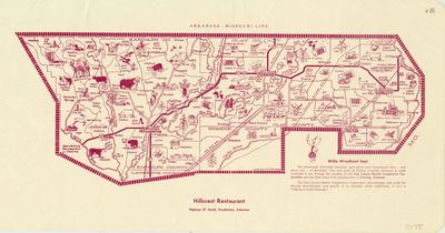
This map of Randolph, Clay, and parts of Greene County Arkansas shows different industrial, recreational, and agricultural features of the area. Its design was once used as a placemat at the Hillcrest Restaurant in Pocahontas, Arkansas. The region the map shows is the service territory of the Clay County Electric Cooperative Corporation, which provided the map. It includes a small section of Lawrence County, but none of its features are on the map.
Biographical/Historical Note
The Clay County Electric Cooperative Corporation was founded in 1938. Willie Wiredhand was created on October 30, 1950, by Andrew McLay as Willie the Wired Hand (a play on the phrase "hired hand"). McLay was a freelance artist working for the National Rural Electric Cooperative Association (NRECA) at the time. In February 1951, the NRECA chose Willie the Wired Hand as their mascot. His name was changed to Willie Wiredhand in short order, and he is still the mascot of many rural electric co-ops today.
Physical Description
Map, 19" x 10"
Keywords
Maps; Agriculture; Recreation; Electricity; Electric cooperatives; Mascots
Geographical Area
Clay County (Ark.); Greene County (Ark.); Randolph County (Ark.); Lawrence County (Ark.)
Language
English
Identifier
Map0175
Resource Type
Image
Collection
Map collection
Publisher
Arkansas State Archives
Contributing Entity
Arkansas State Archives
Recommended Citation
Industrial, Agricultural and Recreational Map of Randolph, Clay and parts of Greene Counties, Arkansas, Map0175, Map collection, Arkansas State Archives, Little Rock, Arkansas.
Rights
Use and reproduction of images held by the Arkansas State Archives without prior written permission is prohibited. For information on reproducing images held by the Arkansas State Archives, please call 501-682-6901 or email at state.archives@arkansas.gov.
Disciplines
United States History
Additional Content
Keywords
Maps; Agriculture; Recreation; Electricity; Electric cooperatives; Mascots


