
Preview
Date Original
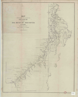
1852
Description
Printed map exhibiting the route surveyed From St. Louis, Missouri, southwest to the big bend of the Red River at Fulton, Arkansas, under the direction of Col. J.J. Abert, U.S. Army Corps of Topographical Engineers. The route displayed on the map follows the route of modern-day U.S. Highway 67.
Physical Description
Map, 24" x 19"
Geographical Area
Highway 67 (U.S.); St. Louis; Fulton, Hempstead County. (Ark.)
Language
English
Identifier
Map2192
Resource Type
Image
Collection
Map collection
Publisher
Arkansas State Archives
Contributing Entity
Arkansas State Archives
Recommended Citation
Map Exhibiting the Route Surveyed From St. Louis to the Big Bend of the Red River at Fulton, Map2192, Map collection, Arkansas State Archives, Little Rock, Arkansas.
Rights
Use and reproduction of images held by the Arkansas State Archives without prior written permission is prohibited. For information on reproducing images held by the Arkansas State Archives, please call 501-682-6901 or email at state.archives@arkansas.gov.
Disciplines
United States History


