
Preview
Date Original
1902 January 15
Description
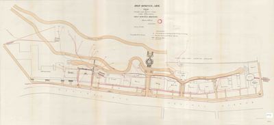
This plan shows several natural springs at Hot Springs, the location of pipe lines attached to them, buildings they connect to, and the roadways around them.
Biographical/Historical Note
The city of Hot Springs was named after the springs there, whose waters have an average temperature of 143 °F and which yield almost a million gallons of water each day. It is said that Native Americans of the areas visited the healing waters of the "Valley of the Vapors" long before European explorers reached the area. President Andrew Jackson designated Hot Springs as the United States' first federal reservation in 1832, and the town of Hot Springs was officially incorporated on January 10, 1851.
Physical Description
Map, 39" x 18"
Keywords
Maps; Hotels; Springs; Hospitals; Bathhouses; Health resorts
Geographical Area
Hot Springs, Garland County. (Ark.)
Language
English
Identifier
Map2191
Resource Type
Image
Collection
Map collection
Publisher
Arkansas State Archives
Contributing Entity
Arkansas State Archives
Recommended Citation
Plan of Springs and Supply Pipes and Other Improvements on Hot Springs Mountain, Map2191, Map collection, Arkansas State Archives, Little Rock, Arkansas.
Rights
Use and reproduction of images held by the Arkansas State Archives without prior written permission is prohibited. For information on reproducing images held by the Arkansas State Archives, please call 501-682-6901 or email at state.archives@arkansas.gov.
Disciplines
United States History
Additional Content
Keywords
Maps; Hotels; Springs; Hospitals; Bathhouses; Health resorts


