
Preview
Date Original
1949
Description
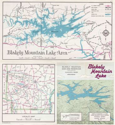
This brochure includes a map of Blakely Mountain Lake, now known as Lake Ouachita, its more immediate surroundings, and where it is situated in Arkansas. It also includes explanations of the dam and reservoir, and the dam building project.
Biographical/Historical Note
The U.S. Army Corps of Engineers constructed the Blakely Mountain Dam and Resevoir between 1946 and 1954 to help control flooding, to provide for the general water supply of the area, for recreation, for fish and wildlife management, to produce hydroelectric power, and to aid in navigation. The project was authorized by the Flood Control Act of December 22nd, 1944, and created what is now known as Lake Ouachita.
Before the construction of dams along the river, the lower Ouachita River Valley area flooded often. As early as 1870, the federal government was considering what could be done to limit the flooding. In the 1890s, the government recommended a series of dams on the Ouachita River above Malvern. The Blakely Mountain Dam, creating Lake Ouachita, was the third such dam to be built, following Remmell Dam that created Lake Catherine in 1924, and Carpenter Dam which created Lake Hamilton in 1932.
Physical Description
Brochure, 17.5” x 16”
Keywords
Dams; Reservoirs; Waterways; Rivers
Geographical Area
Montgomery County (Ark.); Garland County (Ark.)
Language
English
Identifier
Map0297_1
Resource Type
Image
Collection
Map collection
Publisher
Arkansas State Archives
Contributing Entity
Arkansas State Archives
Recommended Citation
Blakely Mountain Lake, Map0297, Map collection, Arkansas State Archives, Little Rock, Arkansas.
Rights
Use and reproduction of images held by the Arkansas State Archives without prior written permission is prohibited. For information on reproducing images held by the Arkansas State Archives, please call 501-682-6901 or email at state.archives@arkansas.gov.
Disciplines
United States History
Additional Content
Keywords
Dams; Reservoirs; Waterways; Rivers


