Files
Download Full Text (682 KB)
Date Original
1918
Description
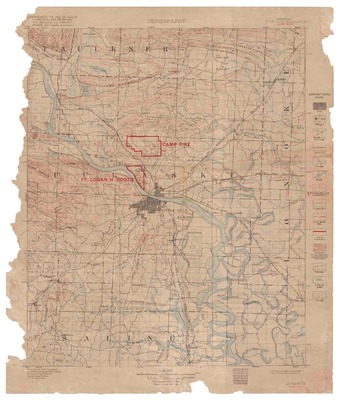
Topographic quadrangle map titled "ARKANSAS, LITTLE ROCK QUADRANGLE, CAMP PIKE" of the Little Rock, Arkansas, and surrounding area, produced by the United States Geological Survey (U.S.G.S) in 1918. The map was originally issued in September 1893 (surveyed in 1891), then reissued in 1918 with land lines and red overprint showing the location of Camp Pike and Fort Logan H. Roots in present day North Little Rock, Arkansas. The map is a 15 minute topographic map with a scale 1:125,000. Contributors listed on the map include: Department of the Interior, Frankklin K. Lane, Secretary; U.S. Geological Survey, George Otis Smith, Director; Henry Gannettt, Chief Topographer; Jno. H. Renshawe, Geographer in charge; Triangulation by S.S. Gannett; and Topography by H.B. Blair.
Biographical/Historical Note
Camp Pike, known as Camp Joseph T. Robinson since 1937, is located in present day North Little Rock, Arkansas. Named in honor of Brigadier General Zebulon M. Pike, Camp Pike served as a home and training camp for the 87th Division (National Army) and then as a replacement training facility after the division deployed to France during World War I. Construction totaling about $13,000,000 on the camp began in June 1917 and was substantially complete by November 1917. The post was a demobilization station and home for the U.S. Third Infantry Division as World War I came to an end. Between World War I and World War II, the camp served as the headquarters of the Arkansas National Guard. During World War II, Camp Robinson became a replacement training center, primarily for basic training and medics, and a German prisoner of war facility. As of 2014, Camp Joseph T. Robinson serves as a 33,000-acre training facility for the Army National Guard and is the headquarters for the Arkansas National Guard.
Physical Description
Map, 20" x 17"
Subjects
Military camps; Military training; World War I, 1914-1918; War; Topographic maps; Maps
Contributor
Department of the Interior, Franklin K. Lane, Secretary; U.S. Geological Survey, George Otis Smith, Director; Henry Gannettt, Chief Topographer; Jno. H. Renshawe, Geographer in charge; Triangulation by S.S. Gannett; and Topography by H.B. Blair.
Geographical Area
Camp Pike, Pulaski County (Ark.); Little Rock (Ark.); Argenta (Ark.); North Little Rock (Ark.); Pulaski County (Ark.); Faulkner County (Ark.); Saline County (Ark.); Lonoke County (Ark.)
Language
English
Identifier
ASA maps collection, Map 1995
Resource Type
Image
Collection
ASA maps collection
Publisher
Arkansas State Archives
Contributing Entity
Arkansas State Archives
Recommended Citation
Arkansas, Little Rock quadrangle, Camp Pike, ASA maps collection, Arkansas State Archives, Little Rock, Arkansas.
Rights
Use and reproduction of images held by the Arkansas State Archives without prior written permission is prohibited. For information on reproducing images held by the Arkansas State Archives, please call 501-682-6900 or email at state.archives@arkansas.gov.
Disciplines
Military History | United States History
Preview