Files
Download
Download Full Text (1.5 MB)
Date Original
1872-1873
Description
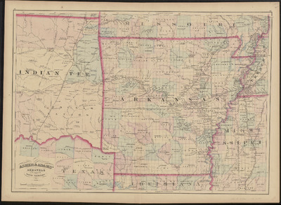
Color map of Arkansas, a portion of Indian Territory, and other neighboring states from 1873.
Physical Description
Map, 24.75" x 18"
Contributor
Asher & Adams, Office of the Librarian of Congress at Washington
Geographical Area
Arkansas; Indian Territory; Louisiana; Missouri; Tennessee; Mississippi; Texas
Language
English
Identifier
Map1315
Resource Type
Image
Collection
Map collection
Publisher
Arkansas State Archives
Contributing Entity
Arkansas State Archives
Recommended Citation
Map of Arkansas and portion of Indian Territory, Map1315, Map collection, Arkansas State Archives, Little Rock, Arkansas.
Rights
Use and reproduction of images held by the Arkansas State Archives without prior written permission is prohibited. For information on reproducing images held by the Arkansas State Archives, please call 501-682-6901 or email at state.archives@arkansas.gov.
Preview