Files
Download Full Text (3.7 MB)
Date Original
undated
Description
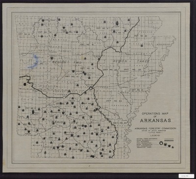
Black and white map entitled "Operations Map of Arkansas" of the Arkansas Forestry Commission, including national forest boundaries, region boundaries, unit boundaries, state headquarters, region headquarters, and observation towers.
Physical Description
Map, 19.25" x 21.5"
Subjects
Arkansas State Forestry Commission; Forest fires; Ouachita National Forest (Ark. and Okla.); Ozark National Forest (Ark.); Fire lookout stations; Watchtowers
Contributor
Arkansas State Forestry Commission
Geographical Area
Arkansas
Language
English
Identifier
Map2987
Resource Type
Image
Collection
Map collection
Publisher
Arkansas State Archives
Contributing Entity
Arkansas State Archives
Recommended Citation
Arkansas Forestry Commission Operations Map of Arkansas, Map2987, Map collection, Arkansas State Archives, Little Rock, Arkansas.
Rights
Use and reproduction of images held by the Arkansas State Archives without prior written permission is prohibited. For information on reproducing images held by the Arkansas State Archives, please call 501-682-6900 or email at state.archives@arkansas.gov.
Preview