Files
Download Full Text (2.7 MB)
Date Original
1955-01
Description
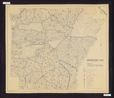
Color operations map of the Arkansas Forestry and Parks Commission, including legend showing private forest area under protection, national forest areas, other federal lands, state fire lookout towers, proposed state fire lookout towers, Co-op Towers, Nation forest towers, proposed usage N.F. Tower, state headquarters, region headquarters, district headquarters, unit boundaries, unit numbers, fixed radio stations, state rangers, state fire plows, number co-op fire plows at single station.
Physical Description
Map, 21.5" x 24.5"
Subjects
Arkansas State Forestry Commission; Forest fires; Ouachita National Forest (Ark. and Okla.); Ozark National Forest (Ark.); Fire lookout stations; Watchtowers
Contributor
Arkansas Forestry and Parks Commission
Geographical Area
Arkansas
Language
English
Identifier
Map0303
Resource Type
Image
Collection
Map collection
Publisher
Arkansas State Archives
Contributing Entity
Arkansas State Archives
Recommended Citation
Operations map of the Arkansas Forestry and Parks Commission, Map0303, Map collection, Arkansas State Archives, Little Rock, Arkansas.
Rights
Use and reproduction of images held by the Arkansas State Archives without prior written permission is prohibited. For information on reproducing images held by the Arkansas State Archives, please call 501-682-6900 or email at state.archives@arkansas.gov.
Preview