Title
Files
Download Full Text (7.7 MB)
Date Original
1854
Description
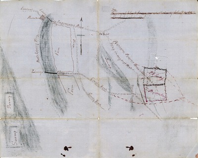
A map of Powhatan and the surrounding area.
Biographical/Historical Note
While this map was created in 1854 once Arkansas was a state, it provides critical evidence for the Territorial period. John A. Lindsay was suing for the right to operate a ferry near Powhatan and to establish a road connecting a nearby town. During the course of the court trial, a map was produced to support Lindsay's claim. Marked on the map are several homes, ferries, and routes which were established during the Territorial period like Black's Ferry. This map shows the locations of these many places which otherwise, would be unknown and lost to time.
Physical Description
Document, 17" x 15"
Subjects
Manuscripts; Maps; Rivers; Roads; Farms; Ferries; Law
Contributor
John A. Lindsay
Geographical Area
Powhatan, Lawrence County (Ark.)
Language
English
Identifier
MSNE.0070, Box 31, Folder 104
Resource Type
Image
Collection
Lawrence County (Ark.) Circuit Court records, MSNE.0070
Publisher
Arkansas State Archives
Contributing Entity
Northeast Arkansas Regional Archives
Recommended Citation
Map, road proposal, Northeast Arkansas Regional Archives, Powhatan, Arkansas.
Rights
Use and reproduction of images held by the Arkansas State Archives without prior written permission is prohibited. For information on reproducing images held by the Arkansas State Archives, please call 501-682-6900 or email at state.archives@arkansas.gov.
Disciplines
United States History
Preview